There will be heavy rain in Guizhou, Guangxi, Guangdong and other places, and there will be high temperature weather in Huanghuai and other places in North China.
abstract:
Domestically, yesterday, heavy rain or rainstorm occurred in Guizhou, Yunnan and other places, and high temperature weather occurred in Henan and Shanxi. It is estimated that from 18th to 21st, there will be a heavy rainfall process from the eastern part of Southwest China to South China. Guangdong, Guangxi and other places are at risk of heavy rain disasters, so pay attention to flash floods, geological disasters and urban and rural waterlogging that may be caused by heavy rainfall. From 18th to 19th, it was sunny and hot in Huanghuai and North China, and the risk of dry-hot wind disaster in winter wheat area was concerned. The Yellow Sea and other sea areas pay attention to the influence of foggy weather on ship navigation.
Globally, yesterday, there was strong precipitation in the Indo-China Peninsula, the southern United States and other places, and high temperature weather continued in India and the Arabian Peninsula. In the next three days, it will be rainy in western Europe and southern Europe, and there will be heavy rainfall on Sri Lanka Island.
I. Domestic weather conditions
1. Reality
(1) There is heavy rain or rainstorm in Guizhou and Yunnan.
From 8 o’clock yesterday to 6 o’clock today, heavy rain or rainstorm occurred in parts of southern Chongqing, central and western Guizhou, western and southeastern Yunnan, southwestern Hunan, northwestern Guangxi, central and northern Hainan Island, and there was heavy rain (100 ~ 132 mm) in Haikou, Hainan. The maximum hourly rainfall in the above areas is 30 ~ 58 mm; Thunderstorms and strong winds occurred in southwestern Yunnan and other places. In addition, moderate to heavy rain occurred in parts of eastern Qinghai, central Sichuan and eastern Tibet.
(2) High temperature weather occurred in Shanxi and other places in Henan.
Yesterday, high temperature weather of 35 ~ 38℃ occurred in parts of western Inner Mongolia, central and eastern Shaanxi, central and southwestern Shanxi, Henan, northwestern Hubei and southern Xinjiang basin, and the local area of Turpan in Xinjiang was 39 ~ 43℃.
2. Key weather forecast
(1) There will be heavy rain in Guizhou, Guangxi and Guangdong.
It is estimated that from 18th to 20th, there will be a heavy rainfall process in the eastern part of southwest China, south China and south Jiangnan, with heavy rain in most areas, heavy rain in parts of eastern and southern coastal areas of Guangxi, central and western Guangdong and southern coastal areas, and local heavy rain. Some of the above areas are accompanied by short-term heavy precipitation, and there are strong convective weather such as thunderstorms or hail in the local area.
From 08: 00 on May 18 to 08: 00 on May 19, there were heavy rains in parts of southwestern Guizhou, Guangxi, western and southern coastal areas of Guangdong, and northern Hainan Island, among which there were heavy rains (100-120 mm) in southeastern Guangxi and other places. Some of the above areas are accompanied by short-term heavy rainfall (the maximum hourly rainfall is 20 ~ 50 mm, and the local area can exceed 60 mm), and there are strong convective weather such as thunderstorms and strong winds. The Central Meteorological Observatory continued to issue a blue rainstorm warning at 06: 00 on May 18th.
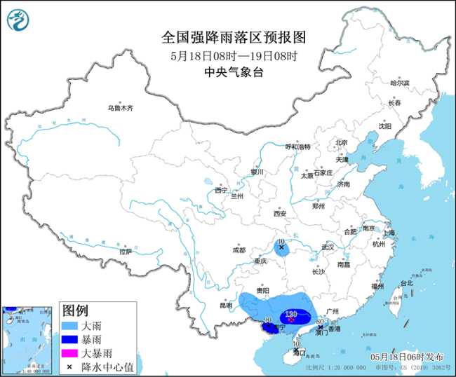
Fig. 1 Forecast of Heavy Rainfall in China (08: 00 May 18-08: 00 May 19)
(2) There is high temperature weather in Huanghuai and other places in North China.
From 18th to 19th, there were hot weather in parts of central and southern North China, central and western Huanghuai, northern Jianghan and Shaanxi Guanzhong, with the highest daily temperature of 35 ~ 37℃.
Second, the global weather situation
1. Reality
(1) Strong precipitation occurred in Indo-China Peninsula, southern United States and other places.
In the past 24 hours, small to medium snow or sleet appeared in northern Eastern Europe, northern Western Siberia, eastern Central Siberia and eastern Far East, and the local area was as big as blizzard; Small to moderate rains occurred in parts of southern western Europe, southwestern central Europe, eastern southern Europe, Caucasus, Turan lowlands, eastern Kazakh hills, Mongolian Plateau, southern Indian Peninsula, Southeast Asian islands, central and western Canada, central and eastern United States, coastal areas of northwest South America, La Plata Plain, southern West Africa and southwestern China, among which heavy rain or heavy rain occurred in western Europe, central United States, Colombia and Paraguay. Dust weather occurred in parts of North Africa, West Asia, Central Asia and southern North Asia.
(2) Continuous high temperature weather in India and Arabian Peninsula.
In the past 24 hours, parts of Mesopotamia Plain, Arabian Peninsula, Indian Peninsula, Indus Plain, Ganges Plain, Northwest Indo-China Peninsula, South-central West Africa, Sahara and its northern area, Mexico and other places continued to have high temperature above 35℃, and the local maximum temperature exceeded 42℃.
2. Key weather forecast
(1) It is rainy in western Europe and southern Europe.
In the next three days, due to the slow-moving vortex trough along the coast of western Europe, rainy weather will continue in most parts of western Europe and southern Europe, and there will be heavy rains in the northwest and southwest of southern Europe; In addition, due to the continuous blocking high-pressure system, most of northern Europe and northern Central Europe are dominated by sunny weather, and the temperature continues to be high.
(2) There is heavy rainfall on Sri Lanka Island.
In the next three days, due to the influence of jet stream and shear system, there will be strong precipitation in Sri Lanka Island, the southern tip of Indian Peninsula and the surrounding waters, and there will be heavy rain and local heavy rain.
Third, the domestic specific forecast for the next three days
From 08: 00 on May 18 to 08: 00 on May 19, there were moderate to heavy rains in parts of western Hunan, northeastern and central Chongqing, eastern Yunnan, most of Guangxi, central and western Guangdong and Hainan Island, among which there were heavy rains or heavy rains (100-120 mm) in parts of southern Guangxi, western Guangdong and southern coastal areas. There are 4 ~ 6 winds in parts of central and northwestern Inner Mongolia, northeastern Heilongjiang, Liaodong Peninsula, southern Xinjiang Basin, Shandong Peninsula and northern Zhejiang (see Figure 2).
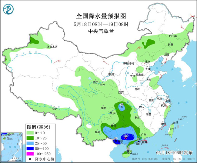
Figure 2 National Precipitation Forecast Chart (08: 00 May 18-08: 00 May 19)
From 08: 00 on May 19 to 08: 00 on May 20, there were moderate to heavy rains in parts of central Jilin, central Liaoning, eastern Hebei, northern Shandong, western Hubei, southern Sichuan Basin, eastern Yunnan, central and eastern Guangxi, most of Guangdong and southern Hunan. Among them, there were heavy rains or heavy rains (100-230 mm) in parts of eastern Guangxi and southwestern Guangdong. There are 4 ~ 6 winds in parts of central and northwestern Inner Mongolia, central Liaoning, southern Xinjiang basin, southern Hebei and northern Zhejiang, among which there are 6 ~ 7 winds in parts of southern Xinjiang basin (see Figure 3).
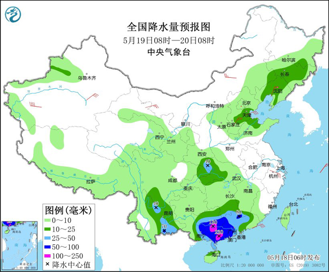
Figure 3 National Precipitation Forecast Chart (08: 00 May 19-08: 00 May 20)
From 08: 00 on May 20 to 08: 00 on May 21, there were moderate to heavy rains in parts of Xinjiang along Tianshan Mountain and Ili Valley, southeastern Chongqing, southern Yunnan, southern Hunan, most of Guangdong, most of Fujian, Hainan Island and Taiwan Province Island, among which there were heavy rains or heavy rains (100-130 mm) in parts of southeastern Fujian, central Guangdong and southern coastal areas. There are 5 ~ 7 winds in parts of southern Xinjiang basin and Hexi in Gansu (see Figure 4).
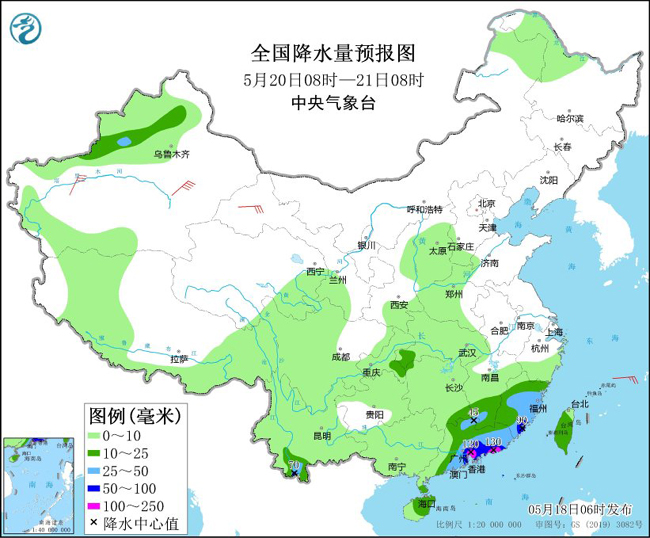
Figure 4 National Precipitation Forecast Chart (08: 00 May 20-08: 00 May 21)
(Editor: Yan Hong)