With the typhoon "Xuanlannuo" away, the people in the "postal area" breathed a sigh of relief.
As the first super typhoon in the northwest Pacific in 2022, "Xuanlannuo" has a large scale, a long duration and a wide wind circle, and it goes all the way from the northwest Pacific to the East China Sea … … Fortunately, after crossing the same latitude in Shanghai on the afternoon of September 5, it continued to move northeast.
Become the "king of the wind"
"Xuanlannuo" is born extraordinary.
On the afternoon of August 28th, it was formed in the region of 25.9 north latitude. This is much higher than the latitude of the general typhoon-generating area (5-20 north and south latitude), which is really rare.
The reason is related to the atmospheric circulation situation and the extreme high temperature this summer. Han Ning, chief service officer of Shanghai Meteorological Bureau, explained: "In the past two months, the subtropical high occupied the northwest Pacific Ocean for a long time, and the downward flow, where the subtropical high prevailed, caused the sea surface temperature to rise sharply, and at the same time, a lot of heat was gathered in the sea, which provided very good thermal conditions for typhoon generation."
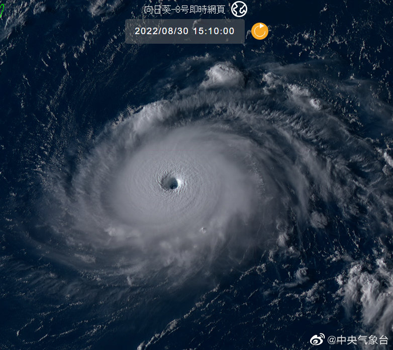
At 15: 10 on August 30, at this time, "Xuanlannuo" has been strengthened to a super typhoon level with clear eyes. Weibo @ Central Meteorological Observatory Map
Subsequently, "Xuanlannuo" was upgraded from a strong tropical storm level to a super typhoon level within 24 hours (from 2: 00 on August 29 to 2: 00 on August 30). At this time, it has a clear eye, a complete and compact ring structure, a small head but strong strength, and belongs to a "short and capable" strength player.
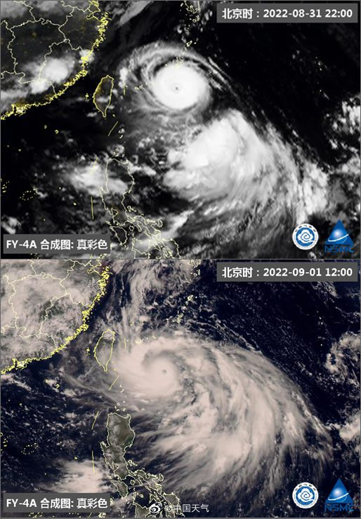
From August 31st to the early morning of September 1st, under the influence of Fujiwara effect, Xuanlannuo swallowed the tropical depression on its south side. Weather map of Weibo @ China
From August 31st to the early morning of September 1st, "Xuanlannuo" accomplished two major events in one fell swoop.
First, it successfully completed the "eye wall replacement". This is a process of self-structural adjustment that is common in strong typhoons or super-strong typhoons. After the successful replacement, the typhoon eye of Xuanlannuo has changed from small to large, making it easier to maintain its strength.
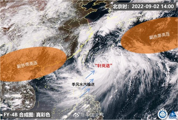
On September 2, "Xuanlannuo" lingered and moved less, and its intensity was downgraded. Weather map of Weibo @ China
The second thing is that under the influence of "Fujiwara effect", it swallowed up the tropical depression on its south side. "Fujiwara effect", also known as "double typhoon effect", usually means that when two tropical cyclones are within 1000-1500 kilometers apart, their rotation paths will be influenced by each other, showing a trend of approaching or even merging.
"Xuanlannuo" has changed from a "short and capable" typhoon to a "big MAC" typhoon with fuller wings.
After the subtropical high was split in two, "Xuanlannuo" was in the saddle-shaped pressure field between the east and the west. Because the steering flow was weak, it kept spinning in the same place, which also led to the upwelling of the lower temperature seawater in the deep ocean, and "Xuanlannuo" weakened to the level of strong typhoon.
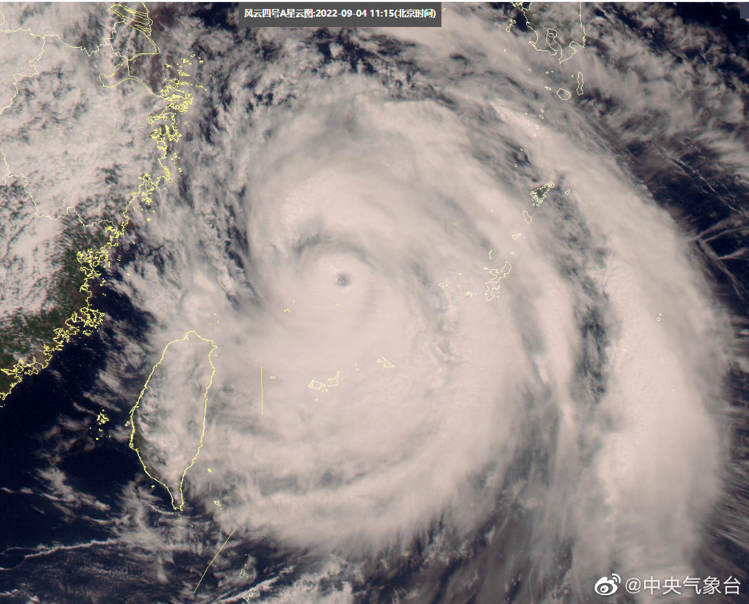
At around 11: 00 on September 4, Xuanlannuo was upgraded to a super typhoon again. Weibo @ Central Meteorological Observatory Map
However, after entering the East China Sea, Xuanlannuo once again absorbed a lot of energy due to the high sea temperature in the East China Sea. At around 11: 00 on September 4, it was upgraded to a super typhoon again. In this regard, Zhou Guanbo, chief forecaster of the Typhoon and Marine Meteorological Forecasting Center of the Central Meteorological Observatory, said that typhoons that reach the super typhoon level in the East China Sea are very rare, and global warming and La Nina phenomenon are the behind-the-scenes drivers that make Xuanlannuo so special.
V-shaped walking
The strangeness of "Xuanlannuo" lies in its "V-shaped position". China Meteorological Bureau said that "Xuanlannuo" has taken a unique path for the first time since meteorological records were recorded.
2-3 days after its formation, "Xuanlannuo" showed rapid explosive growth and moved steadily to the west. This is still related to the stable subtropical high at that time. "The easterly airflow on the south side of the subtropical high, as the steering flow, made the typhoon move steadily westward, which became the trend of its previous movement." Han Ning said.
Walking, starting from August 31, "Xuanlannuo" gradually turned southwest.
This is due to the tropical depression it just annexed. Han Ning said that the tropical depression was on the south side of Xuanlannuo, and this "little brother" was annexed and at the same time led Xuanlannuo to move to the southwest, which became the first turning point in its path.
Then, it happens that there is a high-altitude trough crossing the border in the north. There are low-value system effects on both sides, and the subtropical high is shivering. Unable to resist the attack of two "opponents", the subtropical high appeared "fracture"
Han Ning made an analogy. "The subtropical high is distributed in strips from east to west, just like we usually knead a dough. From the north and south, two fingers pinch, so that the whole subtropical high belt breaks."
The subtropical high was divided into two parts, the east and the west, which also opened the northward passage for the typhoon. However, "Xuanlannuo" was once stuck in the saddle-shaped air pressure field formed by the East-West Ring Road, and steering flow was weak, so it had to keep spinning in the east of Taiwan Province to find a breakthrough.
Two days later, the opportunity came. The western subtropical high weakened, the eastern subtropical high extended westward, and steering flow was re-established. Xuanlannuo took the opportunity to move directly to the north and enter the East China Sea, and its moving speed was gradually increasing. In this way, we have stepped out of the "god walking", that is, the unique "V-shaped walking".
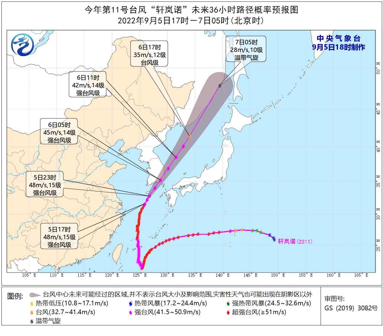
Typhoon "Xuanlannuo" path. Produced by the Central Meteorological Observatory at 18: 00 on September 5.
Subsequently, "Xuanlannuo" went all the way north. At 19: 00 on September 5, it is located in the northern part of the East China Sea, about 170 kilometers west-south of Jeju, South Korea. It is expected to move rapidly in the north-east direction at a speed of about 40 kilometers per hour, and its intensity will slowly weaken.
Bring sultry first.
Although "Xuanlannuo" didn’t land in Chinese mainland, its wind and rain impact can’t be underestimated, with an impact range of several thousand kilometers.
"Xuanlannuo" is gradually approaching Shanghai. Originally, I thought that the typhoon could bring down the temperature, but the first thing that arrived was the sultry weather of Huangmei, and "Xuanlannuo" was wrong.
At 9 o’clock in the morning on September 4, the temperature in Shanghai was close to 30℃, which was quite sunny when there was sunshine, and sultry when there was no sunshine. This is actually caused by the typhoon structure. The typhoon periphery prevails in downward flow, and it will sink and warm up. Coupled with the ultra-high humidity, it will feel sultry and unbearable.
The typhoon came, and the blue sky, white clouds, dark clouds and showers in Shanghai were broadcast randomly. The sun came out for a while, and then it suddenly rained heavily.
In this regard, Wu Rui, chief service officer of Shanghai Meteorological Bureau, explained that the external circulation of typhoon is professionally called "spiral cloud and rain belt". On radar and satellite, spiral cloud and rain belt is a bit like the tentacle of eight catching fish, and it will rain heavily where it is thrown. After throwing it, the weather will improve, so don’t be confused by the temporary calm.
Especially from the afternoon of September 4th, the wind power in Shanghai increased obviously, and it entered the period with the strongest influence of wind and rain.
Statistics of rainfall from 16: 00 on September 4 to 16: 00 on September 5 show that the rainfall in Shanghai is generally above the moderate rainfall level. There are heavy rains and local rainstorms in Jiading, downtown, Pudong, Fengxian and other areas. The maximum rainfall occurs in Nanhui New Town, Pudong, which is 51.0 mm. In terms of wind power, the maximum gust on land generally exceeds level 6. Among them, Luojing Town, Baoshan is the largest, with an 11-level gale of 28.6 meters per second.
At 15: 00 on September 5, the center of Typhoon Xuanlannuo was located on the sea about 358 kilometers east of Shanghai, which was 31.3 degrees north latitude and 125.7 degrees east longitude, and had already crossed the same latitude of Shanghai. At 16: 00 on the same day, "Xuanlannuo" weakened to a strong typhoon level.
Before midnight on September 5, the wind was still strong along the coast of East China. However, with the typhoon away, the impact on the east China coast will gradually weaken, and the people in the "postal area" will breathe a sigh of relief. The combination of typhoon and cold vortex in the later period will also bring obvious rainfall to the northeast.
The Central Meteorological Observatory predicts that "Xuanlannuo" will move to the northeast at a speed of 35-40 kilometers per hour, and its speed will gradually accelerate and its intensity will gradually weaken. It will land or graze the southern coast of South Korea in the morning of September 6, and then enter the Sea of Japan and move rapidly to the northeast, and gradually degenerate into an extratropical cyclone.